| 02/03/2007 | Hydrocarbon potential of Somaliland
M. Y. Ali
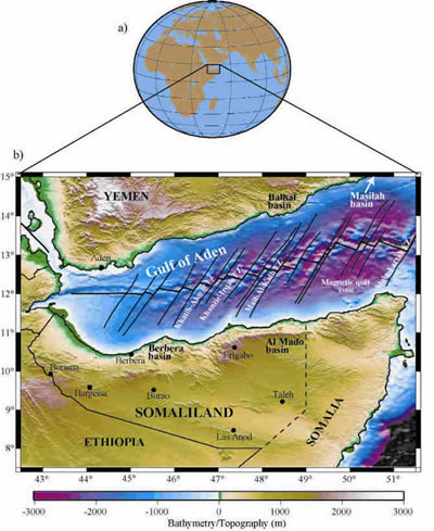
Somaliland (Northern Somalia) is situated on the northern side of the Horn of Africa with the Gulf of Aden to the north, Somalia to the east, Ethiopia to the south and west, and Djibouti to the north-west (Fig.1). The morphology of the country is typical of areas in extension, with basins and mountains of up to 2000 m.
There is little folding, but much normal faulting, some of which has very great throws. These strong vertical movements have controlled the accommodation space available for sediment deposition since the Lower Jurassic.
To date there have only been 21 wells drilled in Somaliland (19 onshore and two offshore), many of which were only stratigraphic tests (Fig. 2). In fact few of the wells evaluated the hydrocarbon potential of the country and the type of prospects in the drilled basins. In addition, modern seismic reflection surveying has had very limited application in Somaliland. Therefore, many prospective petroleum systems in the onshore and offshore regions of the country remain relatively unexplored.
In this paper, seismic, well, and outcrop data have been used to determine the petroleum systems of Somaliland. These data demonstrate that the country has favourable stratigraphy, structure, oil shows, and hydrocarbon source rocks. In addition, the results show that the Upper Jurassic and Cretaceous units, and possibly Oligocene-Miocene units, show potential for hydrocarbon generation. Traps are provided by rollover anticlines associated with listric growth faults and rotated basement faults which are controlled by Upper Jurassic to Lower Cretaceous tensional stresses.
Stratigraphy and depositional setting
The sedimentary section of Somaliland can be divided into four parts (Fig. 2):
Jurassic rift sequences
The Jurassic deposits in Somaliland consist of a thick sequence of continental deposits (basal sandstone formation) resting directly on the peneplain basement rocks and over lain by a succession of limestones (Bihendula group) generally with some marl and shale intervals. Jurassic sediments were deposited in NW-SE trending grabens (e.g., Bihendula graben) that were formed as a result of tensional forces associated with the rifting of India from Africa.
The Jurassic outcrop at Bihendula, 35 km south of Berbera, was the first to be recognized in the country and has since been the most extensively studied. It is where the greatest thickness (more than 1200 m) of fossiliferous marine Jurassic beds are exposed in the country.
Cretaceous sequences
The Cretaceous sedimentation of Somaliland is characterized by lateral lithologic variability resulting from transgressing seas from the east. As a consequence, thick carbonate and shale sections were deposited in the eastern part of the country and equally thick sequences of sandstones were deposited in the west. The widely used term 'Nubian sandstone' has been applied by several workers to describe the entire Cretaceous clastic sequences seen in outcrop (MacFadyen, 1933). However, some authors (Bosellini, 1992) divided the Cretaceous into Yesomma sandstone and Tisje carbonates, although it is difficult to distinguish the different formations due to the transitional nature of the interfingering clastic and carbonate facies.
Eocene sequences
Eocene deposits of Somaliland consist of massive limestones of Auradu and Karkar formations separated by massive to banded gypsum and anhydrites. This is the result of Eocene seas transgressing from the east depositing Auradu lime stones. Periodic regression in the Middle Eocene resulted in evaporatic conditions, which led to the deposition of the Anhydrite (Taleh) series. Further transgression in the Upper Eocene caused the deposition of marine cherty limestone of Karkar formation.
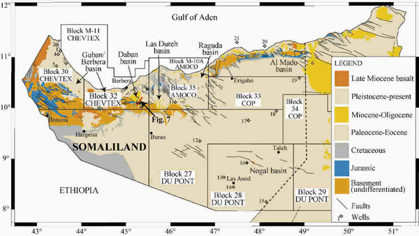
Figure 2 Simplified geological map of Somaliland (modified from Abbate et al., 1993) showing positions of oil wells drilled and major sedimentary basins in the country Legend of wells are: (1) Zeila-I, (2) Zeila-2, (3) Zeila-3, (4) Zeila-4, (5) Heemal-l (6) Berbera-1, (7) Dagah Shabel-1, (8) Dagah Shabel-2, (9) Dagah Shabel-3, (10) Biyo Dader-1, (11) Las Dureh-I (12) Bur Dab-I, (13) Yaguri-I, (14) Las Anod-1, (15) Burhisso-1, (16) Nogal-1 (17) Faro Hills-I, (18) Hedad-1, (19) Buran-1 (20) Dab Qua-I, and (21) Bandar Harshau-1. Also shown are concessions held by various oil companies in the early I990s and the location of the seismic profile in Fig. 7.

Figure 3 General stratigraphic column of Somaliland showing essential petroleum systems in the country.
Oligocene-Miocene rift sequences
Oligocene and Miocene sediments are mostly restricted to narrow and isolated sub-basins along the coastal belt border ing the Gulf of Aden, occasionally extending inland in low lying regions. They deposited in localized grabens caused by the rifting of the Gulf of Aden. They consist of a thick (up to 2500 m) syn-rift sequence of red-brown, green sand, silts, and gypsiferous sandstone. These sediments are almost entirely terrigenous deposited in lagoon, delta, and alluvial environments. The best outcrops of Oligocene-Miocene sediments occur in Daban basin (south-east of Berbera) which is a down-faulted rotated block bordering the Somaliland plateau (Fig. 2).
A summary of the stratigraphy of Somaliland is given in Fig. 3. This figure shows the major formations, general thicknesses, and known occurrences of oil shows in these rocks.
Exploration history
Petroleum exploration in the country began in 1912 when an oil seep at Dagah Shabel, 38 km south-east of Berbera, was reported. In 1959 Standard Vacuum (Mobil and Esso) drilled three dry wells (Dagah Shabel-1, -2, and -3) near the Dagah Shabel oil seep, without the aid of subsurface control. One of the wells recovered free oil from the Wanderer limestone (Upper Jurassic) and Nubian sandstone (Upper Cretaceous). However, no oil was recovered from the follow-up wells.
Interest in oil exploration recommenced in the late 1970s and, in 1980, GECO conducted an extensive offshore speculative seismic survey in the Gulf of Aden for the Somali government. In the same year a vast concession known as the Guban concession was awarded to a consortium consisting of two oil companies, the Quintana Oil Company and Hunt Oil Company. They conducted a detail exploration programme which included an aeromagnetic survey and a seismic programme over onshore blocks 32 and 35. However, after two years they relinquished the concession.
Exploration interest in the country intensified in the mid 1980s during which most of the concessions were awarded to different oil companies (Fig. 2). The Hunt and Quintana concession was divided into two with one part awarded to Chevron and the other to a partnership of Amoco and International Petroleum Corporation. Phillips and Agip also held concessions in the country. Shell was awarded an offshore concession which encompassed most of the Gulf of Aden coastline. However, it relinquished that in 1984 after the failure of two wells (Bandar Harshau-1 and Dab Qua-1), although oil shows were encountered in pre-rift Eocene carbonates and post-rift clastics. The two wells were drilled in block M-10 in water depths of around 300 m.
All of the oil companies operating in the country at the time including Amoco, Chevron, Agip, and Conoco declared force majeure on 11 July, 1989 due to continued civil unrest.
Hydrocarbon plays
The most compelling evidence that oil and gas accumulations may exist in Somaliland, as illustrated in Figs. 4-7, include:
- Occurrence of oil seeps at Dagah Shabel.
- Very good oil shows from several zones in most of the wells drilled including Dagah Shabel wells, Biyo Darer-1, Bandar Harshau-1, and Dab Qua-1.
- Occurrence of mature oil-prone source beds with sufficient levels of organic carbon, together with potential reservoir rocks and structures in a variety of geological settings.
- A number of Jurassic rift basins as well as Oligocene- Miocene sedimentary basins. These include Berbera/Guban (conjugate of Balhaf basin, Yemen), Daban, Las Dureh, Raguda, Al Mado (conjugate of the Masilah basin in Yemen ), and Nogal basins.
- Widespread and appreciable thickness of porous and permeable reservoir rocks together with sealing rocks of Jurassic, Cretaceous, and Tertiary in age.
- Evidence of structural growth during Jurassic, Cretaceous, and Tertiary times, which resulted in the formation of structural and stratigraphic traps.
|
The lack of success in the early exploration wells drilled in Somaliland is primarily due to the complexity of the subsurface geology, and the lack of subsurface control by seismic data. Somaliland is a region of relatively abrupt lateral changes of stratigraphy that is related to the rifting and differential vertical movement during Mesozoic and Tertiary times (Ali, 2005). From post-drill analysis of the failed wells, the majority were as a result of poorly defined trap, thin, or absent reservoir, or due to the seal being either thin or absent. In addition, several of the wells were almost certainly stratigraphic tests. These include Zaila-1, Zaila-2, Las Dureh-1, and Dagah Shabel-3.
Source rock potential
The country contains several good quality source rocks which have potential for hydrocarbon generation (Table 1).
Jurassic
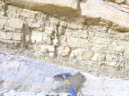
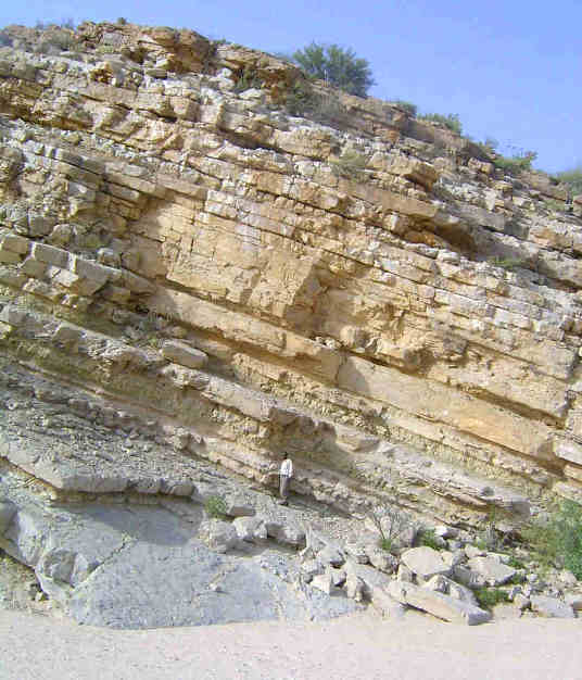
Numerous excellent quality source rocks of Jurassic age are known in outcrops along the coastal margin, including Bihendula area. Gahodleh and Daghani shales are the most important source rocks in the area (Fig. 4). Field investigations in Bihendula area (during July 2005) demonstrated that the Jurassic formations extend approximately 10 km along an east-west striking sequence of limestone ridges and shale valleys that dip generally south at about 17° (Fig. 5). The shales are dark to medium gray kerogen-rich fossiliferous claystones that have fine texture (Fig. 4). It is likely, therefore, that these shales have played an important part in the generation of hydrocarbon in the area. The 28 barrels of 32.2° API oil recovered from the Wanderer limestone in the Dagah Shabel-1 well supports this suggestion. Offshore wells have also indicated good source rocks of Jurassic age. For example, Dab Qua-1 well intersected shales of Daghani formation that had TOCs in the range of 0.53-1.18%.
The results of the hydrocarbon source potential evaluation are summarized in Table 1. As indicated in the table, the composition of the kerogen in samples of Gahodleh and Daghani shales is primarily amorphous (Type I), which are algal remains that have greatest oil source potential.
Cretaceous
The Upper Cretaceous shales of Yesomma formation contain fair to good source potential. In both the Bandar Harshau-1and Dab Qua-1 wells, shales in the Yesomma formation had shown good source potential with TOC up to 5%.
Eocene-Oligocene
The offshore well of Dab Qua-1 encountered a very good potential source rock of 15 m thick and TOC of 3%. In addition, good potential source rocks which had TOC of 11.3% outcrop in the Daban basin, although the succession is immature.
Table 1 Potential source rocks in Somaliland.
| Age and Unit |
Sample Type |
TOC (%) |
Comments |
| Jurassic ( Upper Daghani shale) |
Outcrop |
2.01 |
Good oil source; Type = Amorphous algal; Hydrogen Index = 537 mg/g; Genetic Potential = 11.47 kg/ton; Vitrinite Reflectance = 0.5-1.0. |
| Jurassic (Gahodleh shale) |
Outcrop |
1.43 |
Fair oil source; Hydrogen Index = 434 mg/g; Genetic Potential = 6.76 kg/ton; Vitrinite Reflectance = 0.4-0.9. |
| Jurassic (Calcareous shale) |
Dagah Shabel cuttings |
0.75 |
Good oil source; Type = Amorphous algal; HC/Non HC = 0.57; Vitrinite Reflectance = 0.6. |
| Jurassic (Daghani shale) |
Dagah Shabel cuttings |
0.46 |
Fair to good source for condensate and gas; Type = Amorphous; HC/Non HC = 0.44. |
Eocene/Oligocene (Lignite from
lower Daban Series) |
Outcrop |
11.3 |
Potential gas; immature; Hydrogen Index = 104 mg/g; Genetic Potential = 12.17 kg/ton; Vitrinite Reflectance = 0.4. |
| Upper Miocene (syn-rift shale) |
Bandar Harshau-1
cuttings (650 m) |
1.92 |
Potential gas and oil; immature, Hydrogen Index = 268 mg/g; Genetic Potential = 5.41 kg/ton; No Vitrinite Reflectance. |
| Upper Cretaceous (Yesomma shale) |
Bandar Harshau-1
cuttings (2271 m) |
3.26 |
Overmature; Hydrogen Index = 17 mg/g; Genetic Potential = 0.84 kg/ton; Vitrinite Reflectance = 1.0; Type II/III organic matter. |
| Cretaceous (shale) |
Bandar Harshau-1
cuttings (2268 m) |
1.1 |
Hydrogen Index = 35 mg/g; Genetic Potential = 0.48 kg/ton. |
| Lower Cretaceous (shale) |
Bandar Harshau-1
cuttings (2376 m) |
1.26 |
Hydrogen Index = 21 mg/g; Genetic Potential = 0.35 kg/ton; Type III organic matter. |
| Middle Eocene (15 m thick shale) |
Dab Qua-1 cuttings |
3 |
Very good oil source; Type I organic matter. |
| Upper Cretaceous, Yesomma shale |
Dab Qua-1 cuttings |
5 |
Good oil and gas source; Type II; Genetic Potential = 8 kg/ton. |
| Jurassic (Daghani shale) |
Dab Qua-1 cuttings |
0.53- 1.18 |
Fair oil and gas source; Type II/III organic matter; thin shale (6 m); Type I/II organic matter. |
Thermal maturation and migration
Maturity levels of the source rocks vary from early to post-mature (Table 1). The Jurassic units (Gahodleh and Daghani shales), and possibly the Eocene units in the offshore areas, which may contain multiple source sequences, are situated within the oil window and are highly prospective for oil and gas. In addition, thermal modelling of the Gulf of Aden has identified a number of offshore kitchen areas that have excellent source potential (Bott et al., 1992). Furthermore, seismic and well data suggest both structural migration and strati-graphic migration are operative in these locations (Fig. 6). However, in general the potential Oligocene-Miocene source rocks are likely to be immature to early-mature for the majority of the onshore areas.
Reservoir rocks
The sedimentary strata of Somaliland contain numerous reservoirs within the pre-syn- and post-rift rocks of the Gulf of Aden. Reservoir rocks for the pre-rift sequence include both carbonates (Eocene and Cretaceous-Jurassic) and sandstones (Cretaceous and basal Jurassic). Reservoir rocks in syn- and post-rift sequences are principally sandstones with secondary carbonate reservoirs.
Jurassic
Two onshore wells, Dagah Shabel-2 and Biyo Dader-1, intersected 191 m and 160 m of sandstones in the Adigrat respectively. Porosity of the sandstones was variable, but as high as 15%. At Dagah Shabel-2 they produced fresh water. The reservoir potential of the Middle-Upper Jurassic deposits of Bihen, Wandere, and Gawan limestones is also good.
Cretaceous
In the Upper Cretaceous, good clastic reservoirs have been recognized. Dagah Shabel-1 well intersected very thick (790 m) fine to coarse-graded fluvial sands of the Nubian (Yesomma) formation. The well encountered two highly porous sand units where small quantities (four barrels) of good quality (33.6° API) oil were recovered. In the offshore, the Bandar Harshau-1 well penetrated 536 m of Upper Cretaceous sediments of restricted shallow marine environment that had porosities of up to 14%.
Tertiary (Eocene-Oligocene)
Clastics and carbonates of Eocene-Oligocene age also offer reservoir possibilities in syn- and post-rift traps. In the offshore, the Dab Qua-1 well penetrated a total of 183 m of Auradu limestone that have oil shows. Bandar Harshau-1 well also had minor oil and gas shows.
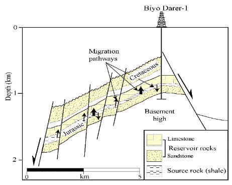
Figure 6 Idealized north-south cross section of Biyo Darer area showing the elements of the petroleum systems. The dia gram depicts three potential migration scenarios: (1) Vertical migration from potential Jurassic source rocks into overlying Cretaceous Nubian formation, (2) Lateral migration from Jurassic source rocks into overlying Jurassic reservoirs, (3) Lateral migration from Jurassic source rocks into underlying Lower Jurassic Adigrat formation.
Traps
In Somaliland, there is no evidence of large-scale compressive folding like that of north-eastern Arabia. However, at many localities in the country, minor folds are known to occur which are believed to have been caused either by rejuvenation of old fault blocks or drag along major faults parallel to the Gulf of Aden. Such folds are mainly confined to the Guban region where the intensity of the faulting has been very much greater than in the plateau. One such example is the minor folds recorded in the Dagah Shabel district, close to the Dagah Shabel fault.
As a result the primary structural traps in the country are rollover anticlines associated with major growth faults that become listric above the pre-rift section. Stratigraphic traps are also important, particularly in the offshore areas where thick successions of Jurassic and Cretaceous sediments were eroded. The seismic profile across the Dagah Shabel and Daban basin, as seen in Fig. 7, provides a sample of the type and density of structures present in the area. The figure illustrates the trapping styles in the area. In addition, the general magnitude of area of uplift of some of the structures might be a guide to possible structural size.
Seals
The country has ideal conditions for seal development. Seals are constituted principally by interbedded shales for the Jurassic and Cretaceous sequences, with Eocene anhydrites also forming a regional seal. For the syn-rift sequence of Gulf of Aden Oligocene, anhydrites and interbedded shales are the main seals.
Comparison with Yemen
The geology of Yemen shows many similarities with Somaliland. This can be supported by reconstructing the Arabian plate to the position before the opening of the Gulf of Aden when many basins in southern Yemen seem to extend to Somaliland. For example, the Balhaf graben appears to be a continuation of the Berbera basin, and Masila basin appears to be a continuation of Al Mado basin (Fig. 1). As in the case of the Jurassic basins in Somaliland, drilling within the Balhaf and Masila grabens have indicated the majority of basin infills are Jurassic and Cretaceous in age. Furthermore, significant accumulations of oil and gas have been found in Jurassic grabens in Yemen including the Masila basin. Therefore, exploration interest to date in Somaliland has centred on searching for Jurassic rifts similar to those in Yemen.
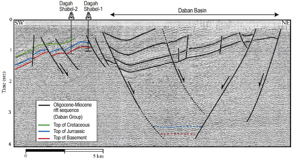
Figure 7 Regional seismic profile crossing Dagah Shabel and Daban basin illustrating a graben structure of the Oligocene-Miocene units and the overall structural style of the area.
Conclusions
The available well, seismic, and outcrop data show that the potential for commercial accumulations of hydrocarbons in Somaliland is good. These data show that the hydrocarbons may have accumulated in numerous large tilted fault-blocks and isolated sub-basins. Jurassic rift basins form the main exploration plays. Secondary exploration targets include Oligocene-Miocene rift sequence of the Gulf of Aden together with underlying pre-rift Eocene carbonates. Hence, favourable hydrocarbon plays could exist over many thousands of untested square kilometres along the entire north coast and south-east of the country at various drilling depths. However, much more exploration work and exploratory drilling activities are needed especially in the basins adjacent to the Gulf of Aden to determine whether Oligocene-Miocene successions are mature.
Acknowledgements
The author wishes to thank Abdirahman Yusuf and the Somaliland Ministry of Minerals and Water Resources for providing the seismic data, evaluation of source rocks, and supporting his visit to Somaliland in July 2005. He also wishes to thank the Petroleum Institute (Abu Dhabi) for supporting this work.
*The Petroleum Institute, PO Box 2533, Abu Dhabi, UAE. E-mail: mali@pi.ac.ae
References
Abbate, E. Sagri, M. and Sassi, F.P. [1993] Geology and mineral resources of Somalia and surrounding regions (with a geological map of Somalia 1:1.500.000). In Abbate, E., Sagri, M., and Sassi, F.P. (Eds) 1st Intern. Meeting on the Geology of Somalia and Surrounding Regions (GEOSOM 87), Florence.
Ali, M.Y. [2005] Petroleum geology and hydrocarbon potential of Somaliland. 67th EAGE Annual Meeting, Extended Abstracts, 283.
Bosellini, A. [1992] The continental margins of Somalia. Geology and geophysics of continental margins. In Watkins, J.S., Zhiqiang, F., and McMillen, K.J. (Eds.). Am. Assoc. Petrol. Geol. Mem. 53, 185-205. Tulsa, Oklahoma.
Bott, W.F., Smith, B.A., Oakes, G., Sikander, A.H., and Ibrahim, A.I. [1992] The tectonic framework and regional hydrocarbon prospectively of the Gulf of Aden. Journal of Petroleum Geology, 15, 2, 211-243.
MacFadyen, W.A. [1933] Geology of Somaliland. Government of the Somaliland protectorate.
Smith, W. H. F. and Sandwell D. T. [1997] Global seafloor topography from satellite altimetry and ship depth soundings. Science, 277, 1957-1962.
Source: First published in first break volume 24, August 2006, © 2006 EAGE Somaliland Times (Somalia)
Otras Notas Relacionadas... ( Records 1 to 10 of 1274 )
|